Saturday 24th September Burton wrote "Descending the western watershed, we sighted, in Deep-Creek Valley, St Mary's County, the first patch of cultivation since leaving Great Salt Lake." and continues " fields extend about one mile from each bank, and the rest of the yellow bottom is a tapestry of wire grass and wheat grass" The photo below shows the valley with the Deep Creek Range behind. The clumps of trees mark the position of the little settlement of Ibapah (pronounced Eye-ber-paw which is Goshute for 'deep water') where Deep Creek Pony Express station was located and where we were headed .....
The Pony Express trail heads across the sage brush in the background.
The present buildings at Ibapah do not date from Pony Express days, but cattle are still raised on grassy meadows near the creek
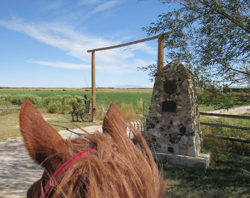
By the Pony Express Monument for Deep Creek Pony Express station just to the south of Ibapah....
Burton reports that the station was dirty and fly ridden, but remarked once again on the hospitality of their Mormon hosts "they supplied us with excellent potatoes and told us to make their house our home" and stressed that the lack of housekeeping was "not Mormon, but Western".
Some mention has already been made of Major Howard Egan, who was a notable figure on this section of the Pony Express Trail, and it is worth recounting a little of his background. He lived here at Deep Creek on a ranch and mail station he established in 1859 about three miles north of the current Pony Express monument. Born in Ireland, he gained his title of Major in the Mormon Nauvoo Legion, and came to Utah in 1847 with the initial Mormon pioneers as a guide and bodyguard to Brigham Young. After working on Chorpenning's Jackass Mail service to California, he was hired by Russell, Majors and Waddell.
He explored much of the Central route to California before Simpson's official survey, and as a local resident with a working knowledge of the trail he was a natural choice for Division Superintendent of the Pony Express service between Salt Lake City to Carson City. After the Pony Express folded, he continued to work for the Overland Mail until it was replaced by the transcontinental railway in 1869.
Two of Egan's sons, Howard Ransom Egan and Richard Erastus 'Ras' Egan, were Pony Express riders, and Howard himself famously took part in the first run when the rider was not in place at Rush Valley (Faust). Taking over the ride to Salt Lake City in a storm, his pony fell off a plank bridge into Mill Creek en route, but Egan recovered and continued, to hand on the mochila successfully!
Leaving Ibapah, we were now nearing Nevada...
...and it was not long before we crossed the border and reached our days' destination of Eight Mile Springs, so called because it was eight miles from Deep Creek.
Burton makes no mention of a station here, but Pony Express rider Nick Wilson describes " a rock building, twelve by twenty, with a shed roof covered with earth so that no timbers were sticking out that the Indians could set fire to. It had portholes in each end of the building and one on each side of the door in front". Just as well, for when he rode up to take over the mail on one occasion, he saw the incoming rider being ambushed and shot by Indians. Wilson was holed up here for three days under intermittent attack until rescued by soldiers. In the house with him were three horses (!) and a couple of orphaned emigrant boys who had ended up stranded and in charge of the station after the station master absconded. Luckily there was water in the cellar which kept them all alive though it was "not a bit good".
A rather cramped camp spot at a junction by the creek at Eightmile, but at least there was a little grass for Lady..
..while Lucy and I were able to celebrate crossing into Nevada with a glass of wine and nibbles....
..followed by supper which Lucy is drumming up in the background. The advantages of travelling in style!
Wednesday 21st September Riding into Callao on the old Pony Express Trail..
After several days tramping through the hot desert, it was delightful to reach this well watered oasis with its green alfalfa fields, tall ancient cottonwoods and the leafy willows which gave Willow Springs Pony Express station its name.
A sign displaying the names and locations of the residents as you come into town!........
We ended up finding a corral and a place to park the rig with the Timms family (second label down on the right) who included Derek and Cindy, and sons Trevor and Devon.
The monument for Willow Springs Pony Express station, which is located down the driveway on the Bagley Ranch...
The station accommodation did not appear to be have been very salubrious, as Burton stated "nothing could be fouler than the log hut; the flies soon drove us out of doors". However "hospitality, was not wanting, and we sat down to salt beef and bacon, for which we were not allowed to pay".
You may just be able to see Lady in her sheltered corral at the Timms Ranch....
We initially parked the rig on the right, but a real gale got up later in the day so we moved away from the huge old cottonwood trees to park by the cattle pens at the back, just in case! Thunderstorms came in overnight and it continued to rain on Thursday 22nd September, so it turned out to be a good time to take the planned day off to re-stock with supplies (propane, gas, food etc) at the nearest sizeable town of Wendover, eighty miles away. Internet access and phone reception had been very erratic or non-existent as we travelled away from civilisation, so it was also a vital opportunity to contact and confirm plans with some of the NPEA members who had kindly consented to help out further west in Nevada.
The Timms run about 250 cattle on their property...
..but this strange beast is actually a dummy steer to practise roping...
Derek Timms is the fifth generation to farm in Callao and their land was bought by an ancestor from the renowned Howard Egan. Derek is also descended from Boyd of Boyds station.
It was a cold damp start to Friday 23rd September as we set off towards Ibapah, and snow was settling on the Deep Creek mountains to the west. I had hoped to stop for a lunch break at the site of Canyon station at the mouth of the narrow Overland Pass, but it was so bleak and windy that after a quick rain drenched photo opportunity we moved on.....
The photo shows Round station, which was a fortified building built in 1863 after the demise of the Pony Express. It replaced previous Canyon stations which had been burnt by Indians, one of them three miles to the west of this point in Overland Canyon. Through the rain and to the right in the background you can see the start of the canyon, a narrow valley about nine miles long through which Pony Express riders had to run the gauntlet.. "Nothing, certainly, could be better fitted for an ambuscade than this gorge, with its caves and holes in snow-cuts, earth-drops, and lines of strata, like walls of rudely piled stone" wrote Burton, who was shown a point where one rider was badly wounded and lost his horse.
We pressed miserably on through the wet and cold, but I managed to get a photo of the Pony Express monument for Burnt Station across the dry stream gully at the other end of the canyon..
The station site was a few hundred yards further west, or in the right hand background of the photo. The station apparently consisted of a log house and stable, and a dugout where meals were cooked and served. It was originally called Canyon station, but acquired its current name after the Pony Express had ended, when it was burnt in an Indian attack in 1863 in revenge for the massacre of a camp of Indians including women and children. All the inhabitants of the station were killed; five Overland stage employees and two soldiers.
The sleet started to clear, and Lucy found a rather exposed camp spot a couple of miles further on by Skinner Spring, where there was a long trough of clear running water. It was bitterly cold with a cutting wind, so to give Lady some protection we put up the corral on the lee side of the rig and Lucy dug out a waterproof rug.
Our camp spot with a scenic backdrop of the snow sprinkled Deep Creek mountains.
Amazing to think that only a three or four days previously we had been riding in temperatures of nearly 100F!
Sunday 18th September . A short ride of about ten miles brought us to Fish Springs, at the foot of the Fish Springs Range, a green oasis in the middle of salt flats and bare hills......
This is now a National Wildlife Refuge. A wetland area fed by groundwater, the Refuge is particularly vital for a wide range of migratory birds which nest and rest here. Some of the maintained ponds take their names from the 300 or so species of feathered visitor - pintail, egret, shovellor, mallard, avocet and gadwall, the last being a dabbling duck I had never heard of before.
It turned into a boiling hot day with temperatures of around 100C, so we were grateful to find a shady spot to camp and while away the afternoon beneath some trees at the Refuge Centre were there is a small cluster of buildings...
..and we were especially privileged to be allowed use of a shower later in the empty bunkhouse, thanks to the very friendly and chatty refuge manager Brian Allen, shown here with assistant Corey...
Brian's young and enthusiastic chocolate Labrador has the appropriate avian name of Widgeon. Having had got over her initial inconvenient aversion to both water and feathers, she is now turning into a useful working bird dog!
The site of the Pony Express station is thought to be a mile further north where the Thomas ranch once stood - now there is only a picnic site in a stand of trees. In 1959, Chorpenning built a thatched shed to serve as mail and water stop, though by the time the Pony Express came through it seems there was a more substantial building - Burton describes arriving in the cold to a roaring fire, supper and bed.
The Fish Springs Pony Express monument is positioned further up the hill along the Pony Express Road, and making an early start to beat the heat on Monday 19th September, Lady and I stopped there as we left the Centre ...
The view from the monument looks out over the Refuge wetlands with its ponds glinting in the morning light, and across to the Dugway Range on the horizon. You can just see the small stand of trees which marks the former site of the Pony Express station. The old trail ran this way at the foot of the Fish Springs range which rises up behind. The Pony Express Road continues north round the end of the range, but from this point there is also a short-cut going straight over the hills to the west, now through private land.
I have already touched upon Indian attack, and we were now well into a section of the Pony Express Trail which was all but shut down in 1860 due to the Paiute War. This started in May 1860, shortly after the start of the Pony Express service, and was sparked off by the abduction of two young Paiute girls in western Nevada by white men. Starting in the west and spreading east as far as Faust, Pony Express stations were attacked and burnt, and station keepers (who were like sitting ducks) killed. Lookout Pass and the intervening stations between Simpsons and Fish Springs were all abandoned and/or burnt at some time during these troubles, Though only one rider is reported to have lost his life, several had narrow escapes. Rider Nick Wilson recounted how he was ambushed near Fish Springs where the swamp came close to a cedar covered rocky point which provided cover for Indians. If he had not also stated that it was on the run east from Fish Springs, I would have hazarded a guess that it could have been at this point heading west on the Pony Express Road, although now there is a notable lack of cedar in the whole area...
Somewhere before here at the start of October 1860 Burton met a party of ten wagons and ninety dragoons commanded by Lieutenant Weed and two officers, indulged in some more 'liquoring up' and "after American fashion, talked politics in the wilderness".. Since the start of the troubles this party had been engaged in dealing with the "Gosh Yutas" or Goshute Indians, a locally based branch of the Ute peoples.
Rounding the end of the Fish Springs Range...
..straight ahead lies the Deep Creek Range, at the eastern base of which lies Callao and the site of Willow Springs Pony Express station. Past the rock promontory the trail swings in a southward loop to circumvent the worst of the Snake River valley alkali salt flat which Burton described as a "wet and oozy plain, in which the mules often sank to their fetlock". The track we were following here made easy travelling in the dry conditions we were experiencing, but in Burton's words "After heavy showers it becomes a soft, slippery, tenacious and slushy mud, that renders travelling laborious".
We camped for the night at the former site of Boyds Pony Express station, where a stone ruin still remains. This view is looking east to the Fish Spring Range, and you can see the outcrop of rock which can be seen clearly across the Snake River valley plain and acts as a distinctive guiding landmark for Boyds...
The building was constructed around 1855 by George Washington Boyd who lived here for around forty years and served as station keeper. Interesting features are the gunports (now collapsed), in the photo one being directly in line with the rock outcrop. There was a spring nearby which supplied very brackish water - this may be just to the east where we passed a scrubby area of mesquite trees.
Friday September 16th After an initial rodeo display which failed to unseat Mike, Mo settled down to the job in hand and we had an uneventful 16 mile ride along the Pony Express road to Simpson's Springs while Mike regaled me with stories about Orrin Porter Rockwell. Rockwell was a legendary Mormon gunslinger and 'Destroying Angel' who among other things acted as bodyguard to Joseph Smith and Brigham Young, and had a ranch just south of here. En route we passed the unmarked site of Government Creek telegraph relay station, where there may also have been a Pony Express station..
Mike beside the Pony Express monument at Simpson's Springs in front of a reconstruction of the original station building, though the actual site is thought to be about 300ft further west.
Simpson's Springs was named by Captain Simpson who recced the Overland mail route between Salt Lake City and California in 1858. George Chorpenning subsequently established stage stations every twenty miles, some of which later served the Pony Express. The significance of Simpson's Springs lies in the fact that it was the last reliable water source on this route between here and Fish Springs, fifty miles to the east. This explains the presence of a solid stone building which served as a home station for the Pony Express.
The presence of water and grazing (albeit sparse) here has attracted a large number of wild mustangs. Although I had ridden past the Green Mountain reserve in Wyoming, I was now actually riding through the mustang territory which makes up large areas of Nevada...
Fifty years ago the numbers of wild mustangs and burros were in decline, and in 1971 the BLM (Bureau of Land Management) introduced a bill to protect and manage wild horses. See the 2014 BLM documentary describing the history and implementation of this bill. However protection resulted in a mushrooming of mustang numbers to the extent that it has threatened not only rangeland ecologies in HMAs (Herd Management Areas) but the welfare of the animals themselves. The BLM have tried to control the crisis with measures such as vaccinating horses with anti fertility drugs, and removing many to holding areas for training and adoption. However the BLM documentary above does not really highlight the scale of the problem.
According to film maker and BLM advisor Ben Masters, there are currently 75,000 wild horses and burros on land that can only support 27,000. Additionally the BLM spends two-thirds of its budget on caring for the 45,000 horses in holding areas, of which only a tiny percentage are adopted. Ben was the driving force behind the film Unbranded which documented how he and three cowboy friends broke in and rode mustangs across country from Mexico to Canada. He aimed to raise the profile of the plight of mustangs and encourage adoption, but in practice it has done little to reduce the huge numbers of horses in holding areas, and the controversial alternative of euthanasia has had to be considered.
There is a mustang herd of around one hundred and fifty horses in the Simpson's Springs area. A distant view of part of the herd grazing on the plain below the campground...
Saturday September 17th and once again it was just my old faithful Lady and me setting out on the trail through an increasingly desert landscape. Difficult to hear the audio on the video below, but the site of Riverbed Pony Express station is just below the peak ahead which is called Table Mountain. Table Mountain is so called because of the flat terrace which surrounds the summit. Amazingly the whole of the lowland area here was underwater and formed part of ancient Lake Bonneville, and it was waves from the lake which formed the terrace. As the camera pans round, Dugway Proving Grounds which the US military use for chemical and biological testing are off to the right.
The monument at the site of Riverbed Pony Express station....
The surprisingly wide riverbed to the east of the station and after which it is named is thought to have been formed when Lake Bonneville was drying up and the water from Sevier Lake drained down to the lower levels of the slat desert, cutting out the now dry river bed in the process. Howard Egan reported that a Pony Express rider narrowly escaped being swept away by a flash flood when he was crossing the riverbed.
There were substantial log buildings here, and a brackish well which was also used to supply Dugway station, but nothing now remains. Several station keepers reported being haunted by 'Desert fairies' but we neither saw nor heard anything out of the ordinary!
Seventeen miles from Simpson's Springs we came to the abandoned Dugway Topaz Well where we camped for the night in the middle of nowhere. Dugway Proving Grounds are to the north behind the water tower and the Dugway Range is to the left of the rig....
Sunday September 18th Lucy is an enthusiastic member of Back Country Horsemen of America and a keen proponent of their Leave No Trace programme which aims to minimise the impact of recreation on public lands. So here she is clearing up after Lady, having taken down the corral which you can see neatly stacked on the side of the trailer. The droppings will be scattered over the surrounding desert scrub.
I made my way to the site of Dugway Pony Express station which lies about a mile and a half to the south and a little way off the road, "about the forlornest spot I ever saw" according to Horace Greeley in 1860.
Water had to be brought in by cask, as there was little success with wells dug here, and even one dug to a depth of 170ft failed to find water. But the failed wells ended up serving more novel uses. William Egan noted "it made a nice place to dump the stable cleaning" and according to another story, Porter Rockwell used one to dump the body of a stage coach driver who had been found dead nearby with an arrow fired into him, presumably by Indians. But there were no threats on the horizon when Lady and I reached the Pony Express monument...
The station here was a dugout - "a hole four foot deep, roofed over with split cedar logs and provided with a rude adobe chimney"(Burton). But all that now remains is the hollow.
Following Pony Express trail markers on up to Dugway Pass...
Dugway Pass was previously called 'Shortcut Pass' but Simpson wrote "Through this pass Chorpenning & Co. the mail contractors, have made a road, but it is so crooked and steep as to scarcely permit our wagons to get up". The photo below of the final stretch up to the pass shows the the line of old stage coach road below and the cuttings formed by the modern vehicle road above....
Unlike Burton, who announced that he 'liquored up' at the top of the pass, we stuck to water .....
The pass forms the boundary between the Thomas Range to the south and the Dugway Range to the north. The name originates from the practice of digging a serpentine trench or dugway for the uphill wagon wheels to keep them level and prevent the wagons from tipping as they negotiated the grades over the pass. Incredible that the world famous Proving Grounds got their name from a small trench on the side of a hill!
Nearing the site of Black Rock Pony Express station...
..off to the right is the Dugway Range which we have just crossed, ahead is the Dugway military Proving Grounds, and to the left are the Black Rock Hills.
In days gone by, without detailed maps and Satellite Navigation, local landmarks would have played an important role in guiding travellers across open and unfamiliar territory, and it was particularly evident in the west that many stations were sited near significant features. The Pony Express Trail often clearly takes a direct route to a gap in the hills or a prominent hill feature. Although nothing much is known about Black Rock Pony Express station (also known as Butte or Desert station) it is obvious it acquired its name from the distinctive outlying rock at the end of the Black Rock Hills promontory......
This view of our camp was taken in late evening facing north across the road with Granite Peak in the background. In the foreground is the Pony Express monument, the concrete base of which made a convenient place to perform my evening ablutions. No-one to scare away even if it hadn't been dark!
Wednesday September 14th and at last we were truly on the road. It was getting late as we arrived at our destination for the day - the site of East Rush Valley Pony Express station about ten miles away. Not much is known about this station, though it was probably a dugout. Here you can see Lucy's rig cosied up to the Pony Express Monument - it was going to be luxury compared with much of my previous travels!
The camper sleeps two people comfortably, and has heating, stove and fridge. Lucy had equipped the trailer with a large water tank, and it was carrying hay and feed supplies as well as extra baggage. It also has a lockable small tack storage area. (For the uninitiated, tack is horse equipment such as saddle, bridle etc) The corral on the right (containing Lady) attaches to the side of the trailer. The corral on the left (containing Mo) is free standing and the panels are joined by Velcro strips. When not in use the corral panels are hung neatly on either side of the trailer.
The next morning Thursday September 15th it was a short ride to Faust, which was the site of Faust Pony Express Station, sometimes also known as Rush Valley or Meadow Creek station. It was named after Henry Jacob "Doc" Faust, a German immigrant with some medical knowledge who ran the station. The valley is watered by a small creek, now called Faust Creek but previously Meadow Creek...
.... and Faust homesteaded 160 acres of meadowland, raising horses for the army and the Pony Express.
In front of the Faust Pony Express station monument...
...although the actual site lies about three-quarters of a mile further south on private land. It was a log building with a pitch roof, and may have served as a home station.
Although I had seen Mo being ridden, and tried him out briefly before buying, I had used him exclusively for packing up to Salt Lake City. His behaviour had been impeccable throughout. Now I hoped to alternate riding the two horses, so after a short lunch break down the road, I saddled up Mo and clambered on. To my utter surprise he took off like a bucking bronco and I flew through the air, luckily landing on the grass verge undamaged apart from bruised pride. At my advanced age I was not keen to tempt fate by trying again, so this was a slight setback, particularly as my cousin Rowena was due to be riding him in a month's time .
I had already arranged to leave Mo with Mike at the end of the ride, so I phoned him to discuss the next move. We decided that he would take Mo back to Eagle Mountain in the next couple of days to ride on a bit, but would come out the next day to ride him alongside me. So once again it back to my faithful Lady while Mo took it easy.
The ride ahead now seemed fraught with danger. First a sign cautioning us to watch out for a local welcome of the warm but inhospitable kind ....
..as wildfires are a common risk in these dry areas. Shortly followed by this notice....
warning of the remote desert conditions we will shortly be encountering.
In Pony Express days of course there was the added danger of attack by Indians.
Arriving at the site of Lookout Pass Pony Express station, and our camp for the night.
A meagre spring provides a trickle of water which was held back by a small dam, now just a rushy area located uphill from the present monument, but I startled a couple of deer looking for a drink when I wandered up there.
It seems that Division Superintendent Howard Egan built a log cabin here in April 1860 to serve as a Pony Express station. After being abandoned in July at the time of the Paiute war, Burton recorded that it was in ruins by September. It was later rebuilt and was run by Horace Rockwell (brother of the renowned Orrin Porter Rockwell) and his wife Libby for over twenty years until 1890. Childless Libby poured all her affection onto her pet dogs, and there is a little cemetery on the other side of the road where they were laid to rest. The story goes that she once even called out the local doctor from Toole, forty miles away, to treat a sick dog on the pretence that one of the ranch hands was ill. Not unsurprisingly Dr Dodds was far from pleased, though mollified when she presented him with a $20 gold piece!
I had timed my autumn schedule so I could attend the Pony Express National Convention which was conveniently being held in mid September, just before I hoped to set out on the second leg. It would be a chance to meet up with old friends and make new contacts for the route ahead. Nevada were hosting the 2016 weekend convention, so on Thursday September 8th Mike and Bonnie Robinson drove out to Fallon with me in the back seat. En route I succeeded in ticking off yet another Pony Express station which has been moved from its original site, this time Ruby Valley station which is now in front of the museum in Elko - here are Mike and Bonnie in front of the old log cabin.
I sat in on a couple of the more relevant convention sessions and gave a slide show presentation of my world ride, but by and large the non riding members (which included me) were left to their own devices during the day, though there were a couple of organised outings which included a trip to a local winery on the Saturday. Social occasions comprised a BBQ on Friday evening, and dinner on Saturday evening. It was great to catch up with some of the wonderful people who had hosted and helped me in Kansas, Nebraska, Colorado and Wyoming, and also meet in the flesh Petra Keller who had sent me an invaluable digital file of the re-ride route several months previously. I was also able to pick brains, identify problem sections and identify those who could give a helping hand through remote waterless stretches in the desert area ahead. This promised to present a real challenge in places as we would be relying on my support driver Lucy Badenhoop's two wheel drive camper which might struggle with some of the non-asphalt roads.
A colourful phalanx of Pony Express riders accoutred in the official uniform of cowboy boots and hat, blue jeans, red shirt, brown waistcoat and yellow neckscarf!
On Sunday September 11th it was back to Mike and Bonnie's house at Eagle Mountain, where Lucy was waiting in the dark having taken a couple of days to drive over from her home near Sacramento.
I had planned to spend the morning of Monday September 12th in preparations before riding the short leg to Camp Floyd in late afternoon. It was a flurry of activity as Lucy and I rushed to do last minute food shopping, stocking up with horse feed, and organising satellite phone hire among a myriad of other things, but the best laid plans of mice and women go awry. We both had interminable technological problems. My email account had been blocked since I arrived in the US, and all efforts to unblock it failed. This had the inevitable knock on effect on further planning. The GPS programme on my laptop refused to work properly so I was unable to download a file of GPS points I had been given by a HAM operator, or even enter points manually, which meant I was going to have to rely on paper maps across some very remote country. In the end Lucy bought a printer and I printed out satellite maps from Google Earth with my planned route across the most remote sections. HQ at Mike and Bonnie's, with Lucy poring over her laptop.....
I eventually managed to get away in the afternoon and set off along the trail from Eagle Mountain to Fairfield/Camp Floyd, ponying Mo behind me.
The small settlement of Fairfield is the site of the former Camp Floyd, which was a short lived US army post established here in 1858 at the time of friction between the US government and the Mormons. Little remains of it now, but across the street from the commissary (now a museum) is Carson House, a stagecoach inn built in 1858 and subsequently serving as a Pony Express station......
Lucy walks over to visit the inn, which is now part of the Camp Floyd State Park museum.
View from the inn to the Camp Floyd commissary and Pony Express monument.
Mike had found a place to leave the horses, so Lucy and I could return to HQ and continue with preparations, but I then went down overnight with a violent vomiting/diarrhoea bug. It meant taking another day out to recover, but at least it gave me more time for planning once I was less green.
Thursday September 1st After a summer spent catching up with domestic issues and planning the final stage of my Long Horse Ride, I flew in to Chicago to continue my journey. You may ask why Chicago rather than Salt Lake City where I finished riding in June. I wanted to drive the intervening distance to pick up items of baggage I had left en route, and also take the chance to visit some Pony Express places of interest I had missed while plodding along on horseback.
But first I picked up my hire car and drove down to Crown Point to spend the night with Debbie Oborn, who has now moved into the lovely old weatherboard house on her new property. And of course catch up with my Crown Point friends!
Then on to Jamesport, Missouri to stay overnight and share a bottle of wine with Patti, who will be taking Lady on as a member of her equine therapeutic team when I reach the end of the road. I was a trifle concerned that I had overdone the tippling the evening before when my bed seemed to be palpably moving the following morning, particularly as Patti seemed oblivious to anything out of the ordinary, But later transpired that there had been a large 5.8 earthquake in Oklahoma, apparently caused by fracking!
...a beautiful antebellum house built by Alexander Majors in 1856
As I hope you can remember by now, Majors was one of the three founders of the Pony Express. He had already built up his own freighting company before joining forces with William Russell and William Waddell in 1855. Unlike William Russell, a risk taker who was the driving force behind the project, Majors was more cautious and conservative. Together with Waddell, he was by no means enthusiastic about the idea of the Pony Express, quite rightly as it turned out. A pious and sober man, it was Majors who is credited with issuing bibles to all the Pony Express riders, and requiring them to swear an oath promising among other things to abstain from intoxicating liquors while in the employ of the company. The number of empty liquor bottles later found buried at some isolated Pony Express stations suggests that the oath was not always adhered to!
A Pony Express statue silhouetted against the sky near Seneca as I approach Marysville that evening...
Sunday September 4th and I manage to clock up a couple of Pony Express stations in Nebraska that have been moved from their original sites. Firstly Willow Island station, which was moved from its original site nine miles further downstream and on the other side of the Platte River to its current site in Cozad town park...
Machette's was originally a two storey building with stables below, but this may be just the top section.
The wedding cake I am posing in front of is Buffalo Bill's Scout's Rest Ranch, which was another must see in Gothenburg...
William Cody or "Buffalo Bill" certainly worked for Alexander Majors and carried messages for the company in his youth. This larger-than-life character raised the profile of the Pony Express through his Wild West shows, but there is doubt over many of the stories which surround him. This includes the legend that he made the longest Pony Express ride, and in fact some buffs believe that he did not ride for the Pony Express at all.
Buffalo Bill built this house in 1886 on a four thousand acre holding he owned, but sold it twenty-five years later for financial reasons. He used it as the base for his touring Wild West shows, and the ranch includes a large restored horse barn.
While riding to Register Cliff in May, I passed the Fort Laramie National Historic Site but did not have time to visit, so early on the morning of Monday September 5th I turned up bright eyed and bushy tailed at the visitor's centre. This iconic site (see my earlier post for brief historical details) was abandoned in 1895, but most of the buildings were sold off to local homesteaders, as a result of which many survive and have since been renovated.
The 1918 construction of a monument by the State of Wyoming and "a few interested residents" demonstrated an increasing concern for the site....
and in 1938 it became a National Historic Site. Since then most of the buildings have been beautifully restored in their existing locations, and it is an impressive attraction well worth visiting. Allow a few hours to enjoy it!
A splendid barrack block ....
which apparently provided all mod cons for the soldiers...
I always keep a lookout for the nearest tornado shelter in these parts, but this is ridiculous.....
A grammatical clue to remind me which country I am in...
Unfortunately on reaching Casper that evening, I discovered I had left my tablet computer behind at my hotel in Torrington, and spent six hours the following day Tuesday September driving back to reclaim it. On top of this I managed to get a puncture in the middle of nowhere in Wyoming. Luckily a passing motorist helped me with the temporary tyre and I limped over a hundred miles at under 50mph into Rock Springs to have a new one fitted. By this time an obligatory moral booster in the form of a Moose Tracks ice cream at the renowned ice cream shop in Farson was in order.
My horseless carriage tour bucket list had included Fort Bridger, but after all this palaver I only reached there in time to have a whistle stop tour before most of it closed - at least the woman at the gate took pity on me and waived the entrance fee! But the highlight for me was the original Pony Express stable in the sutler's complex, which I was able to see from the outside....
..and the inside....
Jim Bridger exhorting passers by to patronise the Jim Bridger store on the other side of the road..
Spent most of childhood living in Malaya before returning to school in London. Taught for ten years then moved back to Welsh roots to raise sheep, ponies and young family. Married with 3 children. I am raising money through the ride for my husband Iestyn Thomas's charity Challenge Aid www.challengeaid.org which raises money for disadvantaged children worldwide through exercise. I breed ponies under the Cwrtycadno prefix see www.cwrtycadno.com


