Sunday June 19th One of the reasons I wanted to reach Eagle Mountain on Saturday was that I did not want to miss the 2016 Pony Express Re-ride, which was scheduled to pass through Salt Lake City on Sunday with Mike participating on his grey Arabian.
The re-ride is a logistical triumph, as every year a relay of riders carry a mochila holding mail over the entire two thousand miles of the Pony Express trail. In each state the ride passes through, the riders are organised into local groups under a ride captain responsible for about fifty to hundred miles of the trail. They ascertain who rides which section, individual riders generally only riding 1-2 miles at a time, though they may repeat this more than once.
Mike was required to ride two sections of two miles in his local area, one from the other side of Camp Floyd just down the road at around midday. However he was informed during the morning that the ride was running four hours late, so he relaxed and planned to drive out a little later.
Bad move as he then had a panicky call from the ride captain to ask where he was - the Utah riders had made up loads of time and were almost back on schedule, and Mike's slot had been given to another rider!
Mike quickly loaded horse and tack into the trailer, we piled into the pick-up and set off for Camp Floyd, reaching it not long before the incoming rider arrived to hand the mochila over to the next rider..
Camp Floyd was a Pony Express station and you can see the Pony Express monument in the background as the outgoing rider trots away. Then it was on to Mike's first ride section on the Pony Express Parkway at Eagle Mountain. Mike saddles up his horse...
...before taking over the mochila...
and loping off down the aptly named Pony Express Parkway....
You can see Lehi and Utah Lake in the background.
It was amazing and rather poignant to think that this same mochila would soon be passing through the hands of so many new friends who had been helping and hosting me over the previous three months.
Saturday June 18th and I knew it was going to be a long day, as I was hoping but not necessarily expecting to get to Mike and Bonnie's home in Eagle Mountain to the southwest of Salt Lake City. An early start with the ever present backdrop of the Wasatch mountains, still streaked with snow..
but first we had to negotiate some built up areas..
Parking the horses while I have a morning coffee stop....
Crossing the river Jordan...
...the river did not stop for me so I had to use the bridge. On the other side I was able to join the scenic Jordan Parkway which runs right through the centre of Salt Lake City, though some of it is supposedly off limits to horses - not this bit though....
A view over the River Jordan to the Wasatch Mountains from the Jordan Parkway...
Midday lunch stop on the parkway with trees to tie the horses and a small creek to water them, plus a picnic area for me..
By this time it was getting quite hot, so the shade was very welcome. The parkway started to peter out soon after this...
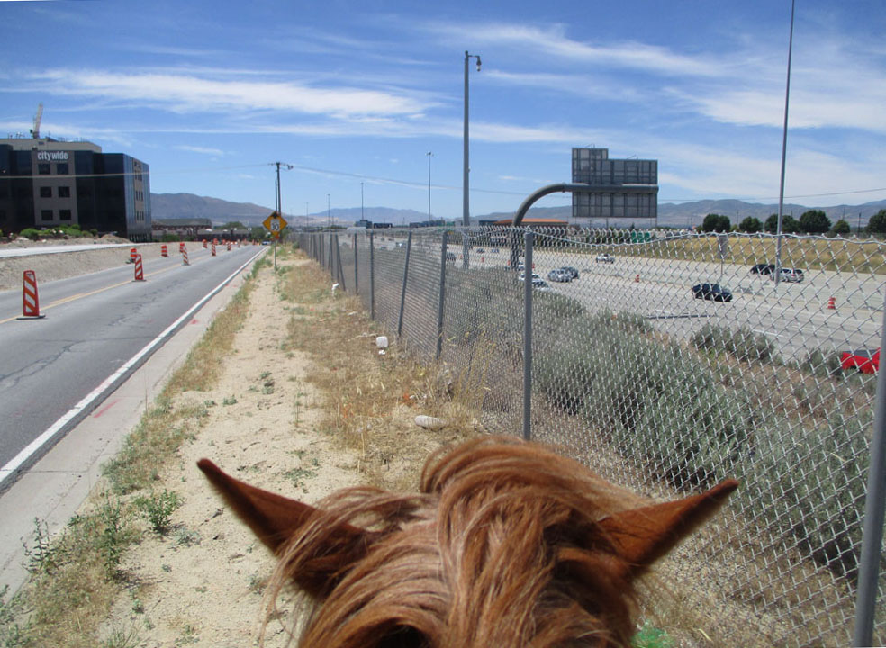
..but I still had a few hours riding, partly along a nasty expressway. Mike trailered his horse Shemai (sounds like the Welsh for hallo!) to guide me in the last eight miles or so as the sun began to set...
...but we eventually reached their home in Eagle Mountain safely in the dark with Bonnie as outrider in the car. A long day, but Lady and Mo were now able to rest completely, Bonnie gave me a choice of luxurious bedrooms and I slept like a log.
A cold dawn start on Friday June 17th soon had us steadily climbing up into the Wasatch...
...past the site of Wheaton Springs Pony Express station, to the summit of Big Mountain...
We were now entering a protected watershed area surrounding Mountain Dell reservoir which provides drinking water for Salt Lake City. I had sorted out the necessary permit, and had with me a plastic sack and a pair of rubber gloves purchased at Grump's to poo pick for the next few miles until we climbed over to Emigration Canyon. Riding along the Big Mountain Creek valley towards the reservoir....
Mountain Dell Pony Express station, also known as Mountain Dale, Hanks' or Big Canyon Creek, was further down the valley on the left, but the site is now under water. The relay station was based at Ephram Hanks' home, which was built as a stage stop in 1858.
Having dumped the bag of poo in a rubbish bin at the next summit, we started on the last leg down Emigration Canyon, along which thousands of Mormon emigrants made their way to Salt Lake City...
About halfway down I came to this small monument marking the 'Last Camp Site' of the First Company of Mormon pioneers led by a rather poorly Brigham Young on July 23rd 1847, before they entered the Salt Lake valley the following day...
In spite of my tooth extraction, I am happy to report that I still got teeth...
We were making good progress, and Mo was becoming inured to the many fitness freaks on speeding bikes whizzing past, when a car drew up. It was newly appointed NPEA president for Utah, Mike Robinson with wife Bonnie, daughter Jennie and grand-daughter Katy. Mike had kindly offered to board the horses for me over the summer and provide a base, and suggested I stop for a meal with them at Ruth's Diner, a noted restaurant down the road. Who was I to refuse, so the horses were tied up in the shade while I joined the family for a delicious meal in shady alfresco surroundings...
We arrive in Salt Lake City! In front of the monument marking the spot where Brigham Young is supposed to have announced 'This is the place'....
... I imagine a no brainer if one has struggled for months across rushing rivers, dry prairies and steep mountains, are feeling decidedly under the weather and are then faced with a view of the Great Salt Lake desert ahead. The three figures at the top of the monument are Brigham Young flanked by pioneers Wilford Woodruff on the right and Heber C Kimball on the left, the latter being an ancestor of Mike's.
Just down the hill was a statue of a Pony Express rider, who you may just be able to make out hurdling the bushes on the right while brandishing an American flag..
I was now riding light, as Mike had taken a lot of my less necessary baggage. I had arranged to stay another eight miles further on at Serendipity stables, tucked away in a residential area of Salt Lake City, but it was a pleasant evening ride through back street areas with non human residents....
The energetic Sue Hall, owner of Serendipity stables, in her flower garden
The horses had a paddock, I had a beer and a shower, and Sue offered me use of her trailer with comfortable bed to sleep in,
Thursday June 16th Leaving the ranch where Heiner Canyon joins Echo Canyon to rejoin the direct line of the Pony Express trail..
This was at a point below the site of Halfway station, also known as Daniels or Emery, which as its name suggests was located about halfway down Echo Canyon. From here on it was possible to follow Echo Canyon road, formerly US Highway 30-S, now an almost deserted side road parallel to Interstate 80. As we travelled down Echo Canyon the scenery became more dramatic with huge sandstone cliffs soaring up on either side...
...and there really was a most amazing echo ringing round the rocks, unfortunately an endless one from the drone of traffic roaring along Interstate 80, so there was no chance of trying it out by voice.
An optimistic buttress?..
By the marker for Weber Pony Express station where Echo Canyon meets Weber Canyon....
This was where the landmark Pulpit Rock was located, destroyed by 1936 partly due to concerns about its stability, and partly to make way for an improved US Highway 30-S.
The station was located by Pulpit Rock, in fact on the other side of the railway line in the background of the photo, nearer the Weber river. Weber Canyon which we were about to follow, leads off to the right. James Bromley, the division superintendent for the stations between Pacific Springs (near South Pass) and Salt Lake City, ran this important station. In addition to the stone station house, there was a general store, inn, saloon, blacksmith shop and jail at the site, and the station provided a good supply of hay and vegetables. The station house was demolished in 1931.
Supplication Hills overlooking Weber Canyon were so called after the first Mormon pioneer group led by a sick Brigham Young camped here. Some of the group climbed the hills in the background to pray for the recovery of their leader and other members who were also ill...
...though apparently they were not so concerned as to prevent them amusing themselves by rolling rocks down the slopes.
I was definitely not grumpy to stop at Grumps in Henefer for an ice-cream...
..and proprietor and retired Salt Lake City policeman Kevin Joiner suggested I stop at his house up the road to rest and graze the horses at midday, an offer I readily accepted. Here is Kevin with an Angus steer he is preparing for the show ring...
We now started climbing up over the first of the ridges of the Wasatch mountains to Hogsback summit..
....which has sometimes also been termed 'Heartbreak Ridge', as after months of hard travelling it must have been heartbreaking for pioneers to breast this summit and see even more ridges of the Wasatch Range lying ahead. I have to say I had some sympathy! However this also marked our entrance into Morgan County, the last county before Salt Lake City.
A view of East Canyon lake from the Highway 65...
The site of the East Canyon Pony Express station is now flooded and lies under the water at the end of this branch of the lake where it joins the East Canyon valley ahead.
I was aiming for the head of the lake another few miles round the corner to the left, and found a spot at the back of a campsite to graze the horses and camp.
We were now near the head of Echo Canyon, where there had been a Pony Express station referred to as Head of the Canyon, Castle, or Frenchie's. I had realised that negotiating the canyon would involve a nasty narrow section where it was completely filled by Interstate 80. Although the re-ride uses the canyon, I did not relish taking two horses down the hard shoulder with semi-trucks careering past on a downhill run, so had secured permission to detour through land to the northwest owned by Ensign Ranches. They are a sizeable concern owning extensive properties including the abandoned ranch where I had just been staying.
On the morning of Wednesday June 15th, we crossed under Interstate 80 at the head of Echo Canyon onto Ensign Ranch land. Jeff turned up to make sure the gate was unlocked, but in fact there was already a handcart trek being organised, and what a lovely day for it....
.. people were arriving as I set off up the Suttons Creek valley. A superb day's ride through some lovely scenery, best described in video clips. A herd of antelope scarper down Sutton's Creek valley..
Riding over the top from the Suttons Creek valley to Heiner Canyon....
...Echo Canyon runs parallel and off to the left.
Riding down Heiner Canyon ...
Uninhabited cowboy cabin near the entrance where I was able to sleep overnight on the sofa while the horses grazed in the overgrown garden...
No electricity, but the boiler was working so I was able to treat myself to a shower after two nights catlick.
After surviving the hailstorm, I made my way to the Diamond X Ranch off Highway 150 to Evanston. Kim Proffit and partner Jill Adams helped me settle the horses into a grassy paddock and invited me into their house for a drink and nibbles before driving me down to the main ranch house where I was to stay with Kim's parents Don and Claudia Proffit....
... a delightful couple who still actively run their large cattle ranch and gave me a warm welcome. Monday June 13th There is a marker for the Bear River Pony Express station at the entrance to the ranch, and Claudia took the photo below for me....
The station was actually a little further down the road by the Bear River. It is thought possible that the wooden barns in the photo below may in fact be the original station buildings...
The station was run by a Mormon Mr Myers.
Crossing the Bear River..
Burton describes the willows and cottonwoods which lined the river at this point and which still abound. From here the Mormon, California and Pony Express trails climbed over the hill ahead on what is now private land. We would have to ride down the Bear River valley via Evanston, though it would be a chance for some quick shopping.
Mo was not at all impressed by this green monster...
but apparently Lady is well acquainted with dinosaurs.
Quick stop at Evanston Walmarts for food, and also pain killers as I was beginning to suffer from toothache..
.
Then we traipsed up the Yellow Creek valley to re-join the trails. Looking back at another important trail landmark - The Needles, a ridge of prominent rocks which can be seen on the skyline in the photo below..
The trails came round to the right of the ridge which is in Wyoming, before climbing up the hill where we are standing which is in Utah, marking another milestone in our journey.
Our accommodation for the next two nights, an empty ranch forming part of......
Ranch manager Jeff Young said I could use the central workshop, and to my relief it had working electricity so I not only had light, but could charge up all my equipment. The buildings were on a large fenced plot with plenty of grass and a small creek running through, so ideal to hole up while I sorted out my toothache which was getting worse by the minute.
Luckily local NPEA ride captain Ron Atkinson came to the rescue, sorting out a dental appointment with local dentist and Pony Express re-rider Nathan Lester for the following morning. Not before time as I had very little sleep overnight with the discomfort. Local rancher's wife Alta Barker ran me into town, Nathan extracted the problem cracked tooth (for free, umpteen thanks!) and Ron dropped me back at the ranch. I took a day off to recuperate and spent most of the time sleeping it off.
Saturday June 11th A short morning ride brought us to Fort Bridger, founded by the renowned mountain man Jim Bridger, who as mentioned before, was portrayed as a young man in the recent film 'The Revenant' and was arguably the first European to see the Great Salt Lake. Jim Bridger evidently recognised a good spot, as you can see we are still in an area of abundant trees and grass...
He established a trading post on the Black Fork's river here in 1842, and it became an important supply post on the emigrant trails. Following friction with Jim Bridger, the Mormons temporarily took control of the post in 1855. During the Mormon/Utah war of 1858 it became a US military post, closing in 1890. Unusually the Pony Express was allowed to use it as a relay station.
Several original buildings from the old fort including the old Pony Express barn still remain, and it is now preserved as a Historic site. Unfortunately I did not have time to stop, and a visit will have to wait until another day!
Shop till you drop?...
We now started climbing up into the hills of the Bear River Divide. We had left the Oregon trail behind as from Fort Bridger it strikes north-west, but were still following the line of the Mormon and California trails as well as the Pony Express trail.
Here are the horses on Bridger Butte looking back to the Black Fork's river valley with the snow-capped Uinta mountains in the background. These mountains run east to west just south of this location.
Riding up the Muddy Creek valley we came to this sign indicating that the Mormon trail crossed here. This is used a location for handcart treks. You may just be able to see the glint of Muddy Creek in the background and the trail winding away on the other side, next to a couple of blue portacabins ready for the next onslaught of trekkers.
The Pony Express trail also passed this way, so this was no doubt the site of Muddy Creek Pony Express station, run by station keeper Jean Baptiste and his English wife.
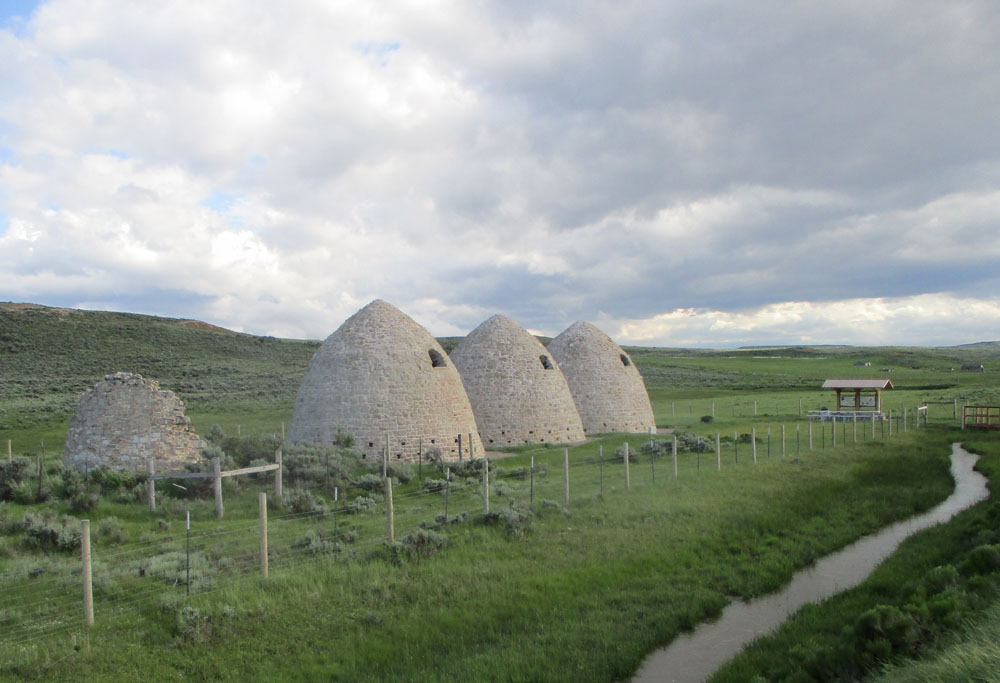
Not enormous bee-hives but restored charcoal kilns at the ghost town of Piedmont, of which little remains....
The town developed from around 1867 as a supply point for the Union Pacific Railway which was originally routed this way. The charcoal kilns were built in 1877 and provided charcoal as fuel for the passenger cars. However after 1901 the railway was re-routed through the recently completed Aspen tunnel just to the north, and the town fell into decline. Apart from the kilns nothing is left but a few wooden ruins.
Piedmont road that I had been riding along actually uses the old railway line embankment.
Arriving at the Guild Ranch where I had arranged to a place for the horses...
Kelly Guild sorted Mo and Lady out with stalls in the barn...
..but I did not need to join them as Earl and Jody Guild invited me to stay in the house, where I had a warm welcome from the houseful of family celebrating Earl's 77th birthday - and jolly spry he looked on it! Daughter Wendy runs handcart treks from the site I passed. A view from the barn over the Muddy Creek...
...I mentioned how similar to Wales it looked with the mountain river rushing through green hills, and Earl said it would look very different in the middle of summer when the river runs dry and the hills are brown!
But as I set out on the day's ride on Sunday June 12th along a quiet track through fabulous scenery, it was still reminiscent of home except for the dry sage brush instead of heather!....
After a fine start to the morning, clouds began to gather, and in the afternoon we even ran into some hail which really upset Lady, though I managed to keep control of her. Mo was unconcerned. Then passing through the small scattered settlement of Hilliard, another threatening thunderstorm boiled up. As I was riding along I heard a weird roaring noise rather like a train coming. It suddenly dawned on me it was the noise of hail pelting metal shed roofs about a mile away. If I could hear it from where we were, it must be serious stuff. I immediately dug my heels into Lady's sides and dashed for the cover at a nearby ranch house, dragging the horses under an overhang just as the hail arrived...
The house turned out to belong to Jessie Lester, who came running out to help me and put away the awning on their RV. Some of the hail was apparently an inch across. It broke the skylight window of Jessie's RV, dented their vehicles and gave her some nasty bruises. I thanked my lucky stars that we had arrived at Hilliard - if I had been caught in the open country I had been riding across all day I suspect Lady would have bolted. During a lull we got the horses into the shelter of the garage, and I ended up staying for a while until the danger was completely past. Any excuse for a cup of tea and a piece of Jessie's delicious strawberry and rhubarb pie! Jessie with husband Ron and little son Nash...
I had in fact passed them on their ATV on the way, but thankfully they also managed to get under cover before the storm hit.
Spent most of childhood living in Malaya before returning to school in London. Taught for ten years then moved back to Welsh roots to raise sheep, ponies and young family. Married with 3 children. I am raising money through the ride for my husband Iestyn Thomas's charity Challenge Aid www.challengeaid.org which raises money for disadvantaged children worldwide through exercise. I breed ponies under the Cwrtycadno prefix see www.cwrtycadno.com